A short history of East Leake
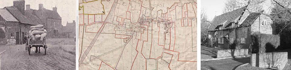
There is archaeological evidence that people have been living on the hillsides round East Leake since the Bronze Age. Like its much smaller twin to the west, our village was probably founded by Angles at some time in the 6th century. Farming in three large open fields, they settled near but not on wet land (leche or leke) in the shallow valley of what is now the Kingston Brook. Their church, St Leonard’s, was probably built of wood which was enlarged, in stone, after 1066 when the Norman overlords arrived. Some 38 individuals were recorded in the Domesday Book (1086) making a total population of about 200-220 living as landholders under two overlords, the Leakes, based in Staunton Harold, and the de Ferrers symbolised by the three horseshoes that are still used as the village insignia. Calke Abbey also came to own land and rights, and two 14th century taxation lists show twelve wealthy farmers and new lords of the manor. This was increasingly an “open village” which soon expanded in a long linear shape along what is now Main Street. Some remaining rig-and-furrow sections of the original open fields can still be seen on Mill Field to the south and the medieval pinfold can be found on the Green. Reflecting the steady expansion of Great Leake, the church was gradually enlarged but retained a rector and his rectory in West or Little Leake leaving a series of curates to tend the souls of the larger community. Over time, the original pattern of ownership changed and splintered as the population continued to grow despite the usual medieval disasters. In 1318 the Treaty of Leake (actually nearer to Hathern) was a short-lived settlement between King Edward II and his magnates.
In modern times the Townlands Trust (1637) and John Bley School (1723) charities helped village development. Social control remained in the hands of the rector and curate, the churchwardens and a village constable. In the 18th century Sir Thomas Parkyns of Bunny bought his way to a significant manorial lordship. To cater for increasing numbers of the poor a small workhouse was built in the Nook. Basketmaking and framework knitting provided new employment opportunities while the Baptist and Methodist chapels (1757 and 1798 respectively) reflected these changing social needs. 1798 brought the enclosure of the old open fields with, now, 50 separate landowners (some in outlying farmsteads) plus the church land and that of three charities. Georgian and Victorian Leake was a thriving mixed community whose more varied economic growth was further helped by the Great Central Railway (1898, linked to Nottingham and London St Pancras) and a growing gypsum industry (BPB). The parish council (1894), however, was slow to invest in public services (electricity, mains water, gas and the Health Centre). In 1945 the population was about 1,500 but grew rapidly from the 1950s with a secondary modern (1956), then a comprehensive school (the Harry Carlton), a second primary school (Lantern Lane), the Catholic church, a supermarket and motorised transport (South Notts bus service from the 1930s). The Great Central Railway closure in 1969 was much regretted as a valuable transport resource though a single line remains open to limited gypsum and leisure use. From a typically small linear farming village of a few hundred Anglian people East Leake has become a much larger multi-faceted “town” with one large employer (BPB), many small industrial units and much professional commuter traffic. A few traditional timber-framed and Jacobean, Georgian and Victorian listed houses can still be seen but most framework-knitting units and all back yards have disappeared. Further housing development is expected and may take the population close to 9,000.
Historical Timeline
|
c. 2500 – 700 BCE |
Bronze Age cremations and mounds on south boundary near St Peters and at Costock |
Prehistory |
|
c. 700 BCE – 100 CE |
Iron Age settlement (round house and enclosures) at St Peters |
|
|
c. 100 – 400 |
Roman coin hoard found in railway cutting. Several Roman sites in locality |
Romans in Britain |
|
c. 450 – 800 |
Anglo-Saxon burials on southern boundary |
Saxon kingdoms |
|
c. 500 – 600 |
Saxon bronze mount and drinking horn found at St Peters (“Rempstone Mount”) |
|
|
c. 700 – 1000 |
Saxon settlement on present village site – “Lecche” |
Saxon unification |
|
c. 1000 – 1066 |
Danes in the area |
Danish kingdom |
|
1066 |
Saxon leaders Godric and Siward |
Battle of Hastings |
|
1086 |
Domesday : 38 families. Henry de Ferrers, Roger de Bully and Ernulf the priest |
Normans under William I |
|
11th century |
St Leonard’s stone church in Saxon style. Probable earlier St Helena’s at West Leake |
|
|
1207 |
First Rector William of Leke. c. 1200 Shirley, Staunton and Leek families |
Early Medieval period |
|
1318 |
Treaty of Leek between Earl of Lancaster and King Edward II |
|
|
1347 |
Two Rectors appointed in one year (Robert de Clypston and Hugh de Wymeswold) which might be evidence of the Black Death in the village |
|
|
1406 |
Court roll identifies 12 frank pledgemen, and 11 non-attenders were fined |
|
|
c. 1400 – 1600 |
Many timber-framed cruck houses |
Late Medieval – Tudor |
|
1637 |
Townlands Trust |
Charles I |
|
1644 |
Civil War skirmish at Costock |
Civil War 1642-49 |
|
1674/5 |
John Bley born at Brookside Farm |
Charles II |
|
1690 |
Bley apprenticed to Distillers Company in London |
William and Mary |
|
1724 |
Bley’s school built on the Nook |
George ii |
|
1731 |
Bley buried in East Leake |
|
|
18th century |
Early workhouse in the Nook |
Industrial Revolution |
|
1757 |
Baptist chapel |
|
|
1798 |
Wesleyan Methodist chapel |
George III |
|
1798 |
Enclosure Act ends medieval open field system of farming |
|
|
1824 |
Anglican schoolroom on the Green. Extended 1850 |
|
|
1830 |
Mills family set up basketmaking |
|
|
1841 |
Census identifies 7 lace bobbin net makers |
Queen Victoria |
|
1844 |
119 framework knitters |
|
|
1864 |
Rev James Garner, President of Annual Conference of Primitive Methodists |
|
|
1874 |
School Board replaces Bley school |
|
|
1881 |
Census : 14 “plaster miners” |
|
|
1888 |
Rev Sydney Pell Potter appointed Rector |
|
|
1891 |
Barnstone Lias and Cement Co. starts gypsum mines at Hotchley Hill. BPB 1936 |
|
|
1894 |
Parish Councils Act replaces Vestry as local government |
|
|
1896 |
First street lamps – oil |
|
|
1898 |
Great Central railway with station at East Leake |
|
|
1919 |
Council houses at Kirk Lee |
George V |
|
1936 |
First piped water and sewerage |
|
|
1948 |
Gotham Road council estate – “Tin Town” |
George VI |
|
1950s |
Village centre redeveloped and new housing estates begun – ongoing. Lantern Lane Primary (1952) and Harry Carlton Secondary (1956) schools |
Elizabeth II |
|
1952 |
Lantern Lane Primary School |
|
|
1956 |
Harry Carlton Secondary School |